
With its lush vegetation, cloud forests, and volcanic topography, Guatemala is a hotspot for hikers from around the world.
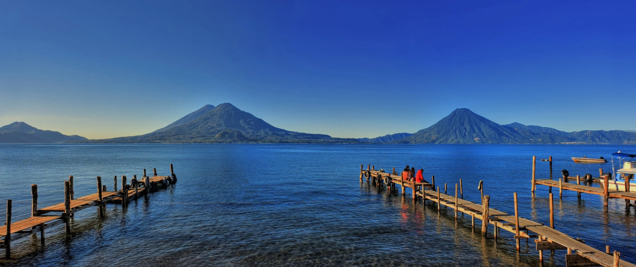
Lago de Atitlá with a view of Volcán Tolimán and Volcán San Pedro. Daniel Mennerich.CC BY-NC-ND 2.0
With its diverse terrain of active volcanoes and green lagoons, Guatemala is a hiker’s paradise. The country’s highland region, which stretches from the city of Antigua to the border of Mexico, is defined by volcanoes in the south and striking mountain ranges in the north. The terrain changes with elevation levels, with areas closer to sea level offering tropical vegetation and playing home to coffee and vegetable farms, while higher points in the country are studded with oak and pine forests. The highest points of elevation, or the altiplano, is a largely treeless area wrapped in a luminous, cloudy coverage.
Antigua, a small volcano-ringed city located in southern Guatemala, is a popular starting point for hikers. The city is considered relatively safe and manageable for travelers and has a rich history and architectural tradition. Previously known as Santiago, the city served as Guatemala’s capital until 1773, when the government decided to change locations due to the city’s devastation from frequent earthquakes and proximity to theAgua, Fuego, Acatenango and Pacaya volcanoes. Today, Antigua is one of the most popular destinations for travelers to Guatemala, offering a diverse celebration of Indigenous culture, history, and architecture, as well as a starting point from which travelers can venture out to some of the country’s most breathtaking volcanic structures.
Companies such as OX Expeditions and Soy Tours can help guide travelers through some of Guatemala’s most intimidating hiking expeditions. Tour companies not only help travelers navigate Guatemala’s diverse terrain and volcanic structures safely, but can also provide transportation options via private buses and shuttles from hiking base camps in Antigua and Guatemala City.
Olcán Acatenango
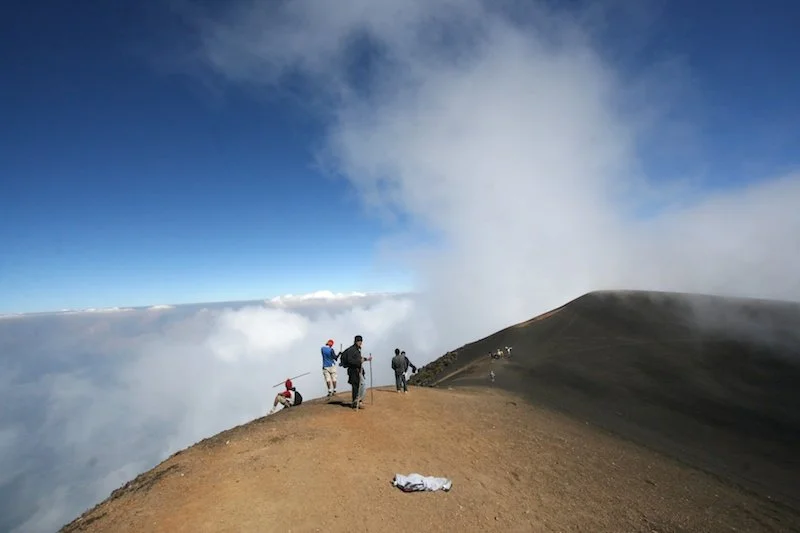
Volcán de Acatenango. NELO Mijangos. CC BY-NC 2.0
With an elevation spanning over 3,800 meters, Olcán Acatenango reigns as the third highest volcano in Guatemala and overlooks unparalleled views of the nearby active Volcan Fuego and Volcan Agua. Acatenango is located in the central region of Guatemala between Sacatepequez and Chimaltenango, and is only about an hour away from Antigua.
Hikers usually opt for an early morning start to make the most of the sunlight hours. Travelers can get to Acatenango from Antigua by car or bus. Most hiking tours are based in Antigua and offer their own private transportation options to get to Acetenango. Hiking Acatenango consists of completing an 8.5-mile loop that takes roughly 7 hours in total, and many hikers will spend the night sleeping on the mountain at their tour company’s base camp. The overnight stay allows one to break up the strenuous hiking while also giving trekkers the opportunity to see the summit of the Acatenango while it's still dark the next morning. Throughout the journey, travelers move through a diverse sampling of Guatemala’s various ecosystems, from farmland to cloud forests to the summit’s volcanic zone.
There are two main routes to summit Acatenango: Alotenango Route and La Soledad Route. Hikers can head towards Acatenango from the pueblo (town) of La Soledad, which has a privately maintained trail offering rest stops and huts along the route to the summit. When descending from the top of Acatenango, travelers can take the same route down via La Soledad or choose a longer pathway through the town of Alotenango. Campsites exist along both routes as well as in the cone of the volcano, however there is no water available on the mountain so it is crucial that hikers plan ahead and bring plenty of their own.
Guatemala’s rainy season spans from May to November, and the best time to get a clear view from Acatenango’s summit is during the dry months between November and January, but weather can be unpredictable and access to warm waterproof clothes throughout the trek is important for all hikers.
Ipala Volcano and Lagoon
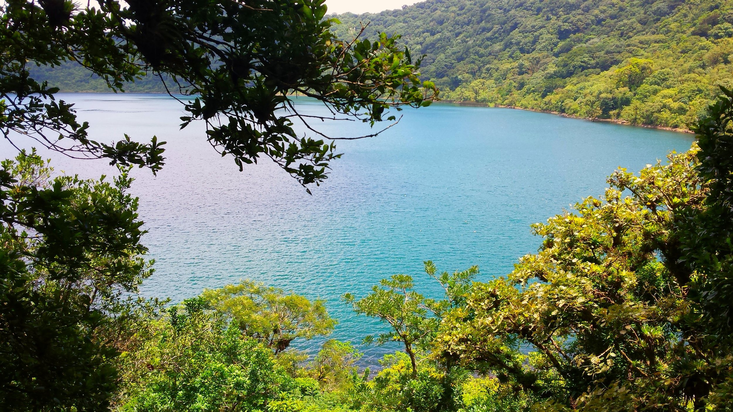
Ipala Volcano and Lagoon. Elder Flores Ramos. CC BY-SA 2.0.
Near the city of Jutiapa, the Ipala Volcano is far less daunting than many of its peers. The hike takes approximately 2 hours, and those who summit Ipala’s 1650 meters are rewarded with an aqua blue lake nestled in the volcano’s crater.
Travelers can get the Ipala Volcano by taking a bus to Ipala from the city of Chiquimula, which is an hour and a half away, or from the city of Jalpa, which is an approximately two hours journey from Ipala. Once in Ipala, buses running to Agua Blanca can drop travelers off at Aldea Sauce, where the hike’s trailhead is located.
The hike offers opportunities to glimpse wildlife and catch views of the nearby Suchitan volcano and the 4000 foot Cerro Monterrico hill.
With a short hiking time and a well marked path, the Ipala Volcano is easily accessible to hikers of all levels, and the lake that sits in its crater is an ideal spot to cool off with a swim while surrounded by some of the world’s most striking vegetation.
Los Amates Waterfall
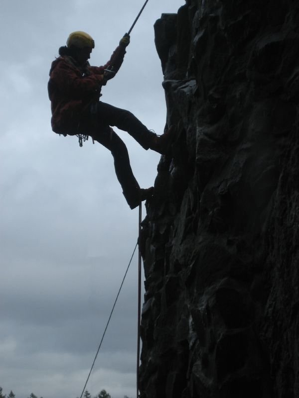
A climber rappelling. Barry Maas. CC BY-NC-ND 2.0.
In the South of Guatemala, stretching some 35 meters tall, Los Amates Waterfall is a picturesque spot for travelers looking to explore off the beaten track. The waterfalls are about an hour drive away from the town of Izabal, which are three hours from the town by foot. The drive to the waterfall is tricky and impossible without a 4X4 vehicle, so travelers often opt to book a private driver to negotiate the difficult terrain.
One of the most popular activities at Los Amates is rappelling, a climbing technique that uses a rope hooked up to an anchor point in order to slowly descend the sheer face of a mountain. Today rappelling has become a sport unto its own, but it also gives hikers an alternative to traditional climb downs, which are often strenuous and difficult to negotiate. Local guides provide opportunities for travelers to rappel at Los Amates with experienced climbers.
Pacaya Volcano
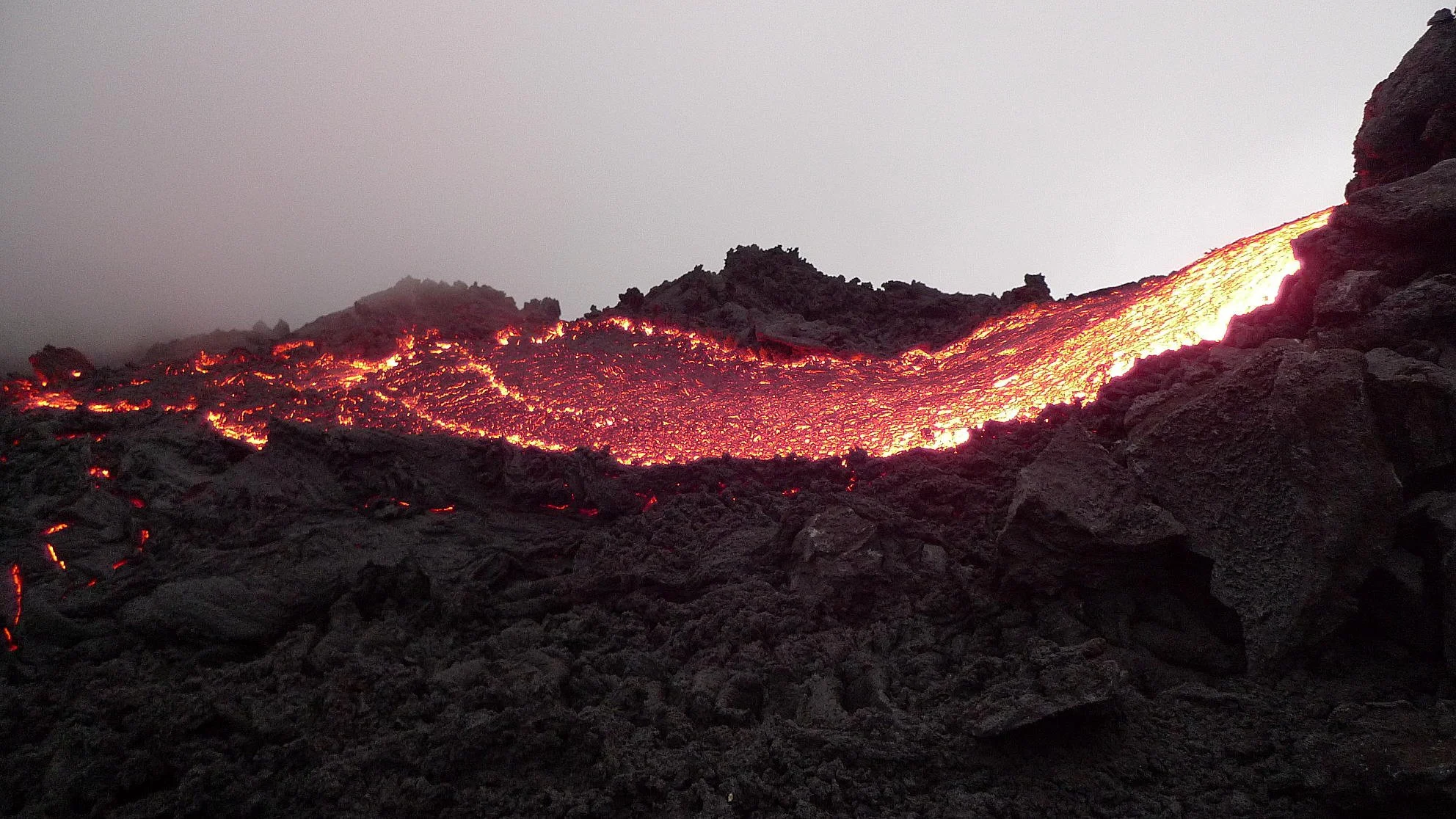
Volcano Pacaya. Beth and Anth. CC BY-SA 2.0
A little more than an hour from Antigua, Pacaya Volcano offers travelers the once-in-a-lifetime adventure to walk along the solidified lava rivers of an active volcano. The hike up Pacaya is a steep and challenging one with a total elevation gain of 2,500 meters that can take roughly three hours total.
While the hiking path along Pacaya is well marked, the challenging nature of the hike and the fact that it involves an active volcano leads many travelers to take advantage of hiking tours. Tours can help travelers explore the lava fields in more depth, roast marshmallows over the volcanic vents, and enjoy a fresh picnic at the top of the summit. Local children often sell marshmallows and hot dogs to travelers who want to try cooking their own dinner against the volcano's natural furnace.

Jessica Blatt
Jessica Blatt graduated from Barnard College with a degree in English. Along with journalism, she is passionate about creative writing and storytelling that inspires readers to engage with the world around them. She hopes to share her love for travel and learning about new cultures through her work.